Interactive Globes is a WordPress plugin that lets users add interactive, customizable 3D world maps to their websites. Below are 10 diagramming & whiteboards apps with similar functionality to Interactive Globes – 3D World Maps, matched by what each product actually does — not ranked or scored. Explore each to find the closest fit for your use case.

Basic Interactive World Map is a WordPress plugin that lets users add interactive, customizable world maps to their websites. It features an easy-to-use dashboard, supports color and link customization, and works on both desktop and mobile devices.
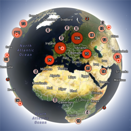
Globe Visitors Counter is a WordPress plugin that adds an interactive 3D globe to websites, showing real-time and historical visitor locations. It is privacy-focused, lightweight, and embeddable, providing instant visual feedback for site owners and marketers.
Interactive Map Widget allows WordPress users to embed interactive maps with custom markers, titles, images, and links. Fully compatible with Elementor, it helps site owners visually display geographic data and enhance user engagement.

Interactive Map of Europe is a WordPress plugin that lets users add a customizable, clickable map of Europe to their site. It features an easy-to-use dashboard, visual editor, and supports both desktop and mobile devices, making it ideal for content creators and businesses.
Planet Pop is a free WordPress plugin that enables users to display interactive 3D planets with realistic rendering, hotspots, tooltips, and animations. It is designed for WordPress site owners seeking engaging visual content.

Code Three 3D Interactive is a WordPress plugin that enables users to build, customize, and embed interactive 3D scenes on their websites using Three.js. It supports multiple models, camera options, and responsive design, making it ideal for designers and creatives seeking engaging 3D web experiences.
MatrixMaps is a WordPress plugin for creating interactive maps using Google Maps or OpenStreetMap. It supports unlimited markers, full customization, and responsive design, making it ideal for businesses, travel blogs, and directories needing map integration.

World Explorer 3D is a browser-based interactive globe that lets users explore real locations, live weather, buildings, and even space. It offers multiplayer rooms, real-time data overlays, and the ability to contribute to a shared 3D world, making it ideal for geography enthusiasts and digital explorers.
3D Viewer is a WordPress plugin that enables users to embed interactive 3D models and 360° product views into their websites. It supports various 3D file formats, touch controls, and integrates with Elementor and Gutenberg editors, making it easy for site owners to showcase products or models interactively.

Max Interactive Maps is a WordPress plugin that enables users to create lightweight, interactive SVG maps with customizable, drag-and-drop pins. It offers responsive design, multiple pin styles, and color controls, making it ideal for site owners who want to display interactive maps without relying on external APIs.
